
The dancing partner of the “polar vortex” we’ll call the subtropical antivortex was the predominant player for much of January across the Inland Northwest and broader western US. Technically, the vortex/antivortex couplet is not an accurate way to describe the regime that lasted much of January. Instead, as the figure below shows it was a large-scale modulation in Rossby wave pattern across the Northeast Pacific-North America with enhanced ridging and troughing over western and eastern North America that were part of a midlatitude wavetrain. Figure shows mid-tropospheric height anomalies, good proxy for temperature and ridge (warm colors) – trough (cool colors) features.
But then again, the term “polar vortex” creates news and fear and rolls of the tongue a lot easier than “persistent mid-latitude amplified Rossby wave pattern”.
 This stagnant regime steered most mid-latitude weather systems well north of the region leading to anomalously dry conditions, though nowhere near as severe as those seen across much of California and western Oregon, places that typically receive 15-25% of their annual precipitation during January. A decent slug of moisture during the last few days of January, brought monthly precipitation numbers up somewhat across the inland northwest, though most locations ended the month with subpar totals.

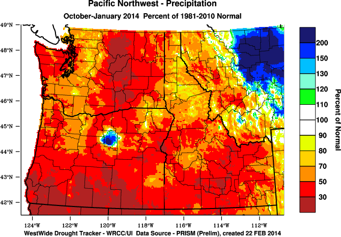
While progressing drought in California has garnered well deserved national attention, the greater Pacific Northwest is not doing so well since October 1st. However, we benefit from not having a lousy water-year during the previous year and being more water-rich than our neighbors to the south. Nonetheless, much of the NW has received less than 50% of the typical amount of precipitation received from Oct-Jan. BTW, I am not sure what is going on in Wheeler County Oregon (least populous county in Oregon, population 1400).
This dry weather has had a significant impact on winter recreation. Some resorts in southern Oregon still yet to open and those in the inland NW not having great years. To add insult to injury, a fire burned down a ski lift in Sun Valley over the weekend. The February 1st snow water equivalent numbers are around 10-30% below normal for northeastern Oregon, eastern Washington and the Idaho panhandle, with 20-50% below normal numbers for much of south-central Idaho. Bad, but again, nothing like the current conditions in western Oregon and into California.

Ironically, the mountains were the place to be for the best weather during January. With a persistent ridge locked in place, inversions socked in most valley locations. Temperatures at 5000-7000 feet elevation were in the 50s for a few days in January with the strong ridge and clear skies in place. Meanwhile, the National Weather Service in Spokane reported the record for monotony at the Spokane Airport with the temperature ranging between 25-30F from the 15th of January through the 27th.

The good news is that after the cold week ahead, the long range weather forecasts look promising in terms of a progressive weather pattern that will feature a some much needed precipitation for the region.
Snowcast 2014 Update
Our first look at snowfall predictions shows the inevitable spread in the distributions. Curiously, the Aneroid Lake SNOTEL station has “normal” SWE as of February 1st, partially due to the generous head start with >4″ of SWE on October 1st. Consequently there is more SWE at the site than total precipitation since Oct 1. Looks like a few folks will be looking to juice snowfall numbers at these two sites in order to capture the title.

