Autumn brings about change. Change for some might be reflected in the transition to orange and red hues of deciduous trees, the arrival of winter-themed drinks at Starbucks, or the conclusion and commencement of MLB and NBA seasons, respectively. October typically brings dramatic change in climatology for the inland northwest. A combination of reduced daylight hours and solar radiation in concert with the typical onset of wet season and associated cloud cover make for a free-fall in temperatures over the 31-days that comprise October. Comparing the climatological high temperature on the first of the month to that of the last of the month yields the following, rather depressing map.

Most spots in the NW outside of the direct marine influence typically see a 10-20F drop off in high temperatures during the month. The results for minimum temperature are less dramatic, resulting in a huge decrease in the diurnal temperature range. Precipitation amounts averaged over the last week of October are between 50 to 250% greater than those for the last week in September across the western half of the inland northwest, extending southward along the Pacific into California. Nonetheless, this is what we should expect to transpire over October.
October 2012 was no exception. The 23-27th of the month brought low elevation snowfall to Missoula as daytime highs across much of western Montana into eastern Washington struggled to make it out of the 30s. For the month, most locales in the region had slightly below normal temperatures, though rather balmy conditions (particularly for overnight lows) the last few days of the month with a warm-moist west-southwesterly flow aloft. The bipolar nature of weather regimes during the transition season were exemplified during a four-day span in Pocatello, ID which set a record low on the 27th of 13F, only to set a record high of 75F on Halloween.

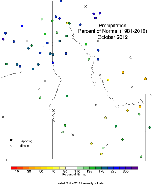
The precipitation during last three weeks of October put an end to the long fire season and quickly added up, particularly across the northern half of the region. The above normal precipitation is a nice start to the water year. Some snow accumulated in the mountains, although the warm moist air toward the end of the month brought mostly rain to locales below 7000ft resulting in a decline in early season snow water equivalent for many SNOTEL sites. We should see a return to much colder conditions later this week as a closed upper-level low migrates out of the gulf of Alaska bringing cold and unsettled conditions to the region. I don’t think this will have enough moisture with it to pile up significant snow amounts, but I do expect Les Schwab to be busy by weeks end.
Snow Lottery
‘Tis the season to submit your well-informed guesses on the amount of snow that would fall over the upcoming winter season. Last year’s winner, Michael Jennings, narrowly edged out our friend Climatology. The forecast this year is to predict the total snowfall accumulation for our reference station, Moscow, ID through 31 March, and the snow water equivalent at the Bogus Basin SNOTEL station on 1 April. The forecaster with the lowest summed absolute error will be crowned in early April. If you would like to take a stab, please do some via the following poll. The poll will be open through the end of the week, closing Nov 9th. Like other votes you may cast this week, I encourage you to do some background research before visiting the poll.
